
russell seemed to be taken aback when i yelled out to him from the window. he was in the middle of checking out the garbage in the bins of the house behind me.
was almost a pack rat to-day heading out. am excessively nervous that all these snaps that i have taken will not turn out due to camera error from the age of them. waking up i used ubirajara around the house photographing little ikons – brought a close up lens precisely for this. for the goal of bell island i took ubaldo, ubirajara and both lenses for it. i was worried about having to carry all of this but was driving and the saab has a boot…
a pleasant surprise – bauline line has been paved – almost all of the road in portugal cove has been the bauline part is still rutted dirt with small rocks in the middle painted orange to show you the middle of the road. bigger rocks – those capable of keeping the bottom of the car are marked with an “x”. saw the reason houses were sprouting up faster in portugal cove than anyplace i had seen so far. worse people were putting in mainland type of lawns which seems futile and strange out here. passing a house the evening before, i even heard the shush shush shush of a lawn sprinkler.
one more new trait about the rock, people are going the speed limit. when 50 meant 80 and the transcanada was the autobahn now people are actually going under the maximum. luckily i knew i a short cut to the ferry. double lucky as the person i was following didn’t make the ferry. got i the queue which for me was at the top of the hill. got out to look at conception bay and the rockette in the distance. the bloke in the saturn in front of me came up and says that it is great over there. he hasn’t been over in three years but tries to get back pretty often. was born over there his father worked in the iron ore mines since he was 12 that i should go down number 2 mine. he lives now in killigrews – poor chap. he counted the cars in the queue and thought that we would both make it.
snaked up to the window paid the $5,25 and went to the top deck of the ferry made famous in the shipping news – the beaumont hamel. stood on the ocean side of the tickle and not five minutes out – it is only a 20 minute ferry ride – four whales played tag with the ferry until they got bored and headed out passed bauline.
expanding on the thesis of when we get weepy – kennedy and david leaving etc. my eyes swell up with this stupid passage to bell island. i think that the province somehow brainwashes one into equating water passage with the rock.
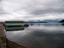
photograph the irving gas towers while docking and follow the queue of cars up the steep hill to wabana making a note to photograph around the ferry when i have to wait this evening.
compared to bell island the avalon is tame the cliffs rolling. here everything seemed to drop abruptly at least 200 feet.
wabana seemed like a town that would be used if we had scruncheon westerns instead of spaghetti ones. the town seemed to be on the earth not in it. very open even though some way from the bay every house seemed to have a view of it. the town centre has a monument to the s.p.c.a. passed an irvings gas bar with with linda’s grill, passed the princess pub – because when you enter you are treated like royalty. i was heading for the mines. – not hard to find as at each interection there was a sign pointing to the #2 mine.
pulled in paid my $7,00 and was warned that the temperature in the mine was 6c if i brought a sweater i should get it. i didn’t but there were spare ones down below.
we all found hard hats that would fit, for a jacket i chose a stunning number – blue mundy pond slow-pitch logo-ed one. we then headed down. pretty impressive once the wailing baby was sent back to the surface. after reading orwell thought that mines were narrow and claustrophobic the hall were quite big and spacious. best part was when they doused the glim to see what the place was like when it was functioning. it supposedly was under all the island and extended under the bay – 600ft under the bay. we could only go about 100 metres as the mine was flooded beyond that. supposedly it was safe – only 104 deaths in the tens of thousands of people who worked there and never an disaster. labrador put it out of business as there is still ten times amount of iron ore that wasn’t extracted.
then the fun stuff started. no sooner than i drove off that i stopped, a giant wall of labatts blue cases awaiting to be taken back to st. john’s, three conveniences, two bars, laundry was everywhere. i kept stopping but also because the map was so bad i was also getting lost – as lost as one can be on a island so small. i didn’t know how far west i was.
on the map i saw an airstrip and a ball park, wanted to photograph both but couldn’t situate myself.
the reason i risked the trip was tj’s car, i always feared that with a real rental i would be charged if the car was nicked. in the end there was no worry about that at all. but now i was extremely careful of the saab. tj was now a friend and i didn’t want to ruin the saab. due to this where before i would have bounced down pitted dirt tracks in whatever the car rentals would have given me, reckoning that they know what the roads are like. this time at the first hint of a rut, i’d park the saab and walk further.
the first was to this hut on the back of the island. it seems that i didn’t have to walk the extra mile as people were driving closer arriving encountered this cliff that had a piece of land as high separated from it. had a look and then a look down to see people on the beach and a cave. they entered it, i was game and followed.
later found out that i had stumbled on grebe’s nest. when the mines closed the people built a tunnel from one beach to another so as to bath. again high cliffs on three sides of a beach only 100 yards long. rock, shale, grey stone and canadian light bottles.
the people i had followed were from sudbury so they were giving the mines a miss both of the men were minors. back to the car to wander a bit more trying to get down to freshwater when i finally spotted the ball park – being used – gave it a miss – but found two more conveniences - one in use, one vacant – and in the distance saw the entrance what i think was the scotia mines. heading toward that saw the airstrip. film was being used up faster than i thought – i had taken 15 rolls thinking that would be more than enough and probably would have been if i had taken the lens cap off ubaldo and not have had to duplicate some shots. others were duplicated out of sheer paranoia. went through a bit here as this was obviously the place people went to do all sorts of nefarious things – found a hair brush on the road outside the mine head – left after freshening up? graffiti, tagging, the way the minehead was situated one way made it look as if it headed under the bay, the other a subway coming to the surface.
in the distance the airstrip, paved a few numbers and markings but nothing else. photographed carefully as i could see something landing while i was walking it.
back on the main road to freshwater, the view of the sea left and what was scrub no trees really at all everything completely open, houses sitting on the earth, became treed with the landscape that i am used to in the north east avalon. sped along as there were few cars – a lot of bicycles – even on the avalon more bicycles and more people walking. sped a bit much as a missed the parson’s lounge and the freshwater inn. the road turns back to wabana at that point along the tickle.
turned around to photograph the building using as an excuse, if i were asked, their rates. it was a bar. made a few snaps when a person comes out and we chat. they will have rooms probably next year. gave me the history of the place made a couple of snaps of him. when he told me to go and have a look at pulpit rock the dirt road just before the bend.
pointed to the saab and asked in that? yeah there will be quite a few paths pick the best. headed up newfoundlanding nodding to the people on their decks someone was mowing the scrub.
he was right there were many paths but all of them looked pretty bad. parked the car hid ubirajara – left it open so that the film wouldn’t bake. st. john’s is safe – even though house break-ins are up 35%. pouch is safer. bell island locking anything would be silly. walked from there. walked to a fence, that was being put up, kept going to another saying private property no vehicles, following the atv tracks that was flattening orchids and other rare flowers – as they weren’t so rare in this field. stopped to pick some raspberries, if i had had raspberries like this i wouldn’t have hated them so. the path came close to the edge of the cliff where again there was a pebbly beach with a 200 foot tower in the bay. got as close as i dared, then continued to this mini cape st. mary’s another rock in the bay separate from the island with nesting birds – not the manhatten type of build colony at apes st. mary’s with birds on every inch of surface this was a nice suburban type of colony – tasteful amounts of space between them. glad that i had walk down to see what was here.
on the hill in the distance where i had parked there was another car people were out of it staring out at where i was. i tried waving to have them come as they were missing the good stuff. they looked and got back in and drove off.
that is the problem with the rock – and rockette – when to stop, i headed to another stunning cliff. wondered what was beyond the next hill. i give myself a time limit and time was up. it is always a problem here as a lot is not accessible by road and well worth the walk.
on the road back a stop at lance cove and a pretty pathetic beach – families trying to have a good time. in the slip area teens were hanging out staring at the slip. photographed the beach, grilles and at the end of the beach a caravan with four chairs neatly arranged out front.
photographed some school bus shelters, more conveniences and bars, a stations of the cross between lance cove and wabana. finishing the tourist circuit i headed over to the light house where i saw wisconsin sized people staring out at the sea.
headed back to wabana to have a walk about. wanted to photograph the spca monument and the irving gas bar. parked by one of the many murals around the island this one depicted the minors and was a monument to those who lost their life.
while making my way around the town i photograph all sorts of social clubs, but not the bar cheers – complete with the cheers logo – nothing really special about it. the businesses were closing, the streets were empty. nice juxtapositions the grotto of jesus with the newtel microwave tower behind it. aliant protest signs at the old newtel property, main street was so deserted that a woman skated along it without worries.
found the perfect ikon for the province church and irving. the princess lounge – looked o.k better than the satellite down toward flatrock. thought about returning to bell island as when i was heading to the ferry, saw another section that i had missed.
headed to the bottom of the hill pretending to photograph the beach area around the ferry but didn’t plan it right. the ferry was there and i was sixth in the queue. on i went exchanged experiences with a video toting bloke who pronounced the province new found land – naturally i photographed him and his daughters.
$50 worth of gasoline was put in the saab – at the irvings mainway of course.
wednesday is the 187th running of the regatta – if it doesn’t rain and it isn’t too wind
on the pond in quidi vidi – the city is on holiday and so is the blog.


Science and Art
-
The teaching of the sciences and the arts needs to be conjoined and
sustained from the earliest stages of education. In the Foreward to
Platinotype my frie...
2 years ago
No comments:
Post a Comment