

the driving to-day would have to be like the driving in the states and ontario, it is 900 km from the ferry to pouch cove, the ferry arrived three hours late, and i wanted to make a stop in bonne bay which would add another 160 clicks to the driving.
while the fog was nice visually i was hoping that it would let up as it only seems to get denser. i knew where not to stop if i wanted to make time - the tim’s in town as that was where half the ferry was racing to and the hotel where the other half headed.
stopped at the interpretive centre for a map, checked the gasoline gauge and sped up to corner brook.
well did stop once, hitting the wreckhouse the fog lifted and the long range mountains were bathed in two different tones of light. by the time stopped it had changed but it gave me the chance to look for my sunglasses. the ferry can be unnerving as everything needed for the crossing has to be carried up, there is no returning to the machine once the voyage is under way. i stuck my sunglasses somewhere thinking that we would arrive at six and that i wouldn’t need them for the crossing. now with the sun blazing i had to find them.
this crossing was going to be hard for i was passing all the places i wanted to photograph -the port-au-port peninsula, through the bay of islands, jackson’s arm were the relatively accessible ones on full day’s driving along a road that led to one destination - burgeo and the bay d’espoir highway were another matter.
thought about a double double at the tim’s in marble mountain while filling up - but thought again when i saw that everyone had the same idea.

it started to rain heading up to wiltondale from deer lake.
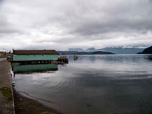
the turn off down route 431 to bonne bay was great and horrible like the drive but this would be the place where traffic would back up as people would be heading into the park gobsmacked -lomond, glenburnie, shoal brook, winterhouse brook and woody point.
jumped out of the car at the discovery centre to see if kris was working so that i could hand in to her “just because” i had wanted to write the explanation for this but hadn’t the chance. the aim was to talk to her frankly about whether the park would want it for the person who was running the programme when i was there either was intimidate by the residents or felt that we were a nuisance. i didn’t make all this work to have it languish in a basement and justifying the book with “it will be a line on the cv” didn’t was with me either.
leaving the residency, talking with a former resident who now was a resident of town - it seems that bonne bay rivals pouch cove for that - she only looked dejected saying that it could happen.
entering saw jessica who was back at the park, winters in topsail summers in bonne bay. we chatted - a hurried chat as i needed to get back on the road. kris wasn’t around gave the book to jessica, saying that i would write in detail - which i have yet to do.
leaving someone was asking about the residency as i passed.
-how did i get in?
-apply five times get rejected four. i said in that determined walked but trying to be friendly sound in my voice.

outside i regained newfoundland time and chatted a bit, told her more about gros morne, other residencies in the province and handed out the e-mail.
i was off for a coffee - to take away from granite coffee - which now has wifi and slowed me down as i tried to get in contact with those on the avalon - and the road. stuck my tongue out at deb, crystal came from the kitchen at the granite coffee, saw amanda head into pete’s but no one else.
i was gone back to a part of the prvoince i am not familiar with as i am always speeding through it. i also realised the difference between the mainland including cape breton - and the rock. the roads on the main land connected populations with each other. on the rock that was done by sea until recently. because of this there are few coastal scenic highways - and those that exist except for the avalon - where there because it was the easiest route.
the tch is a spine everything links to it, so that goods can make it to either the ferry or st. john’s. grand bank on the burin can be seen from harbour breton but i am guessing it takes 12 hours to drive. the reason it winds as if the planner had palsy is to get the road as close to as many outports as possible not to connect them that was done by sea.
route between harbour breton and grand banks
route between burgeo and harbour breton
that is what made the difference - not in what i saw in the maritimes but their significance - a closed convenience did mean a population on the edge as there was no next town a wal mart means salvation as some mainland “townie” seems to think your area will survive.
i came from it backwards. first coming to the rock, i experienced the emptiness, the space between communities, i was now used to checking the gasoline gauge as not only may there not be a gasbar in the next town but there may not be a next town. the warning entering the burgeo highway next fuel stop 140km check your levels. this is why i thought the maritimes nice but “safe”.
this is also why around central newfoundland i became a bit out of sorts. grand falls/windsor and gander the road became more crowded, it didn’t slow but there was more traffic. stopped at a gasbar and the tim’s where people were talking about the ferry mess we all relating our own stories.
tried to have a picnic at joey’s lookout in gambo but the picnic tables were gone, only one bench remained. while the traffic increased still felt better skirting the bonavista after leaving terra nova. the road didn’t go through anything any more but was again more of a spine albeit with somewhat shorter ribs.
i was welcomed to the avalon by fog at the isthmus, once again meaning that i wouldn’t be able to see water on both sides but somehow feeling strange if it were any different.
the refineries at come by chance -sign of the new “have” province.
i realised that i prefer western newfoundland more now at the first sight of the twin cities - there has been so much progress and growth around st. john’s that it is becoming more like anyplace else. i had a clue of this with the new tarted up signs along the highway.
the road to pouch cove was as frustrating as ever due the growth in torbay, saw the beginnings of the bypass.
rolled up to the pipe house, traded insults with my evil twin and all was peachy.


No comments:
Post a Comment