
The rain had stopped and if I delayed it would crest before I could get out.
This area is hardly calming –under the biggest coal fired power plant in southern Wisconsin, past a rampantly growing industrial park in which buildings are constructed even though there are those that are left empty, a pathetic human made lake and the outlet malls all of which are safe from flooding.
It seems that the rains has chased the deer from the woods are five watch me pass on the I-94 frontage road.
Stopped along County Trunk ML and realise that this is going to be difficult – flooded rivers are only noticeable when one knows the boundaries. The Des Plaines was high but subtlety so. Only when I noticed along the banks that the trees were underwater but this was only interesting in the way that the light reflected of the water through the trees.
This was going to be a difficult outing. I was out searching for things and worse searching for specific things. I was heading to the usual flooding places and wanting to deal with the less harmful aspects of the water.
A stop at Russell Road just west of the village – the north side flooded the bar by the tracks dry (yeah yeah hah hah) where there was a bridge in the middle of the water.
Trains passing in the distance.
Back down Kilbourn Road where there was a hope for a decent day. The stereotype of flooded rivers was undermined by fields filling up from run off. Tried to make something of this but was forcing the issue.
Into Wadsworth and the carpark of the Des Plaines River Trail – after a train passed. Again the water looked aesthetically pleasing – if brown – rather than flooded. Flooding as nostalgia.

Gave up on the Des Plaines and headed over to the Illinois Fox passing through that great mistake of Gurnee, north of Six Flags, south of Gurnee Mall.
I know that I was too single minded as I was heading through an area of road houses that I have been meaning to sketch off. I justified my not stopping on the threatening skies.
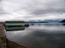
It was the day of the aesthetic flood. I was relieved that those living of the Chain of Lakes were so far unscathed. Stopping in the State Park there were again those little signs of flooding which could also be sign of decay – a fishing pier that was now an island. People in their machines looking out over the river.
By now I gave up – was now simply going through the motions. I didn’t know what I wanted to see – certainly not disasters. This was a good thing as I do like going out with an open mind as I am not illustrating but trying to understand what is in front of me. I think that i was imaging an equivalent of the proof that a tornado had passed through a field when I was out and about in January – everything normal except for those giant oaks ripped up at the roots surround by those that are unscathed.
Stopped at Fox River park to make a few bucolic snaps of picnic tables and grilles - odd I was disappointed as the river wasn’t as high as it usually is here there was still a place to park.

Mechanically drove up Fox River Road to State Road 50 again a forgone stop on the flooded river route but now I was on automatic.
Saw a house that seemed almost bucolic in the middle of the river, US flag proudly flapping.
Maybe next time.


No comments:
Post a Comment